Level 1: System Context
The System Context diagram shows AClimate as the main system surrounded by its external entities. It helps stakeholders understand where the platform fits in the larger ecosystem.
Diagram
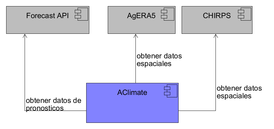
AClimate (Main System)
AClimate is the main platform of the ecosystem. It is responsible for processing, storing, and serving agroclimatic information to different users and organizations. The platform collects climate data from external sources, processes it to generate indicators and forecasts, and presents the results through web interfaces that farmers, extension agents, and researchers can use to make informed agricultural decisions.
External Systems
AClimate connects with several external systems to obtain the data it needs to function.
Forecast API
This is an external service that provides climate forecast information. AClimate consumes this API to obtain seasonal and sub-seasonal weather predictions, which are then processed and presented to users as part of the platform's forecasting capabilities.
AgERA5
This is a global gridded dataset of daily meteorological variables developed by the JRC of the European Commission. It provides consistent high-resolution spatial data on temperature, precipitation, and solar radiation. AClimate uses this as a secondary source of spatial climate data for generating indicators and analyses.
CHIRPS
This is a spatial precipitation dataset developed by the University of California at Santa Barbara. It combines satellite observations with station data to provide daily rainfall estimates at approximately 5 km resolution, going back to 1981. AClimate uses CHIRPS as a primary source for historical precipitation monitoring and spatial climate services.
Users of the System
The platform serves different types of users. Farmers and producers access climate forecasts and agronomic recommendations to make decisions about their crops. Extension agents use the platform to advise farmers on planting dates, cultivar selection, and risk management. Researchers access historical climate data and processed indicators for analysis and model validation. Administrators configure the system parameters and manage geographic and crop entities through the admin portal.